An Overview Of Our Solution
In every community live vulnerable individuals living independently because support systems deliver life enabling services. When disasters strike interruption of critical services puts these people’s survival at-risk. While the size and composition of this population is not well defined, estimates put our regional number between 20,000 and 30,000, approximately two percent of the population. Approaches have been tried and centralized systems put in place to identify and facilitate the care of at-risk residents during emergencies. The majority of attempts have proven marginally successful due to their reliance on centralized systems to capture data and deploy resources. Vulnerable individuals have resisted being categorized as such and centralized deployment quickly breaks down during a catastrophic event.
A consortium of organizations is testing the notion that identification of an ill-defined and ever-changing population and delivery of services that increase their survivability during disasters takes:
- A hyper-local, decentralized effort
- Collaboration among nonprofit, government and the public
- Deployment of innovative information technologies
- Frequent contact to ensure tools, people and process for responding
- Pilots to determine the proper recipe for success
- Population Impacted: 20,000 to 30,000 (approximately 2% of Pop.)(est)
- Continent: North America
Address
810 Union Street
Norfolk, VA 23510
United States
Hazard
Identify the likelihood and frequency of this hazard
Explain how vulnerable the community is to this hazard
List the potential affects of this hazard
Identify how sensitive the community is to these affects
Preparedness Goal
Implementation Actions
We are launching a pilot in neighborhoods where individuals at high to medium risk of vulnerability reside that are at risk for severe flooding. Working with service providing agencies we are identifying individuals whose survivability requires outside support services. We are recruiting volunteers, equal to the identified vulnerable population number, to serve as temporary support service providers during emergency events. Volunteers, who must live within walking distance of an identified vulnerable resident, are being recruited from local civic leagues, neighborhood associations, nonprofits and faith-based institutions. Through the pilot we are testing:
- receptivity of vulnerable residents to accept assistance from local volunteers during emergency events when traditional support service providers are unable to reach them;
- specific roles volunteers can and are willing to play during an emergency event;
- how communication technology can be configured to facilitate neighbor-to-neighbor planning and enable implementation of strategies for providing life-sustaining support services during emergency events (when traditional service providers are unable to respond).
A local information technology firm is building a communication platform to enable volunteers and vulnerable residents to input specific action plans, identify backup strategies should the primary plan fail, provide real-time feeds on weather conditions, location and availability of hyper local resources including shelters, feeding programs, evacuation routes, medical and other services available during the emergency event. All within a secure environment that allows access to the volunteer and vulnerable resident only.
The pilot integrates a faith-based initiative underway to identify local assets that can be deployed during emergencies. Faith communities are identifying their community’s ability to provide temporary shelters, food, medical and other service at neighborhood sites. Hyper local level information describing these services will be delivered to the volunteers through the secure connective network giving the most up-to-date information on what hyper-local resources are available to assist their assigned neighbor
Describe Your Solution
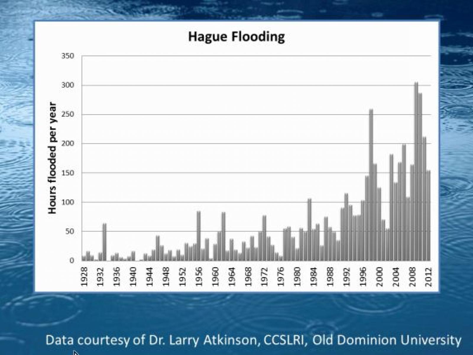
Our solution envisions a neighbor to neighbor approach to ensuring the survival of at-risk individuals living in neighborhoods at high-risk for flooding. During non-flooding periods, these individuals are able to live semi-independently with the assistance of service providers. During severe flooding events the ability of these traditional service providers to reach vulnerable populations is compromised. Thousands of residents move from vulnerable to at-risk for survivability during severe events. Our emergency services system is unable to accurately identify or meet this increased need during a severe flooding event. Vulnerable populations are often unwilling to self-identify using centralized data collection systems run by government agencies. The regional planning agency currently administers such a self-identifying data system designed to provide emergency services agencies the location of vulnerable residents and their support needs during an emergency event. For a regional population of over one million, slightly over 100 residents have used the centralized system to identify their location and need. Using a hyper-local and neighbor to neighbor approach, we seek to establish relationships at the block level that will enable vulnerable residents to receive life-sustaining supports during emergency events when traditional service providers are unable to respond.
By providing a connecting technology that provides specific planning questions that allow neighbors to come to agreements on what services are needed and what can be provided, we believe we will increase the likelihood that vulnerable residents put at risk by an emergency event will be able to survive until normal services are restored. By providing volunteers with specific actions to take and manageable technology to understand the extent of the threat and the available resources, we will give them the tools to provide life-sustaining services to a vulnerable neighbor for a short period of time.
Economic?
While we are still in the piloting phase, we are already seeing results of pulling together nonprofits, faith-based, government and private sector including:
Better identification of vulnerable populations
Development of technology that allows hyper-local information to be distributed to program participants for actionable use including: storm information, travel route information, sheltering information, basic service information, medical service availability, etc.
We have through our Neighbors Building Neighborhood initiatives worked with volunteer groups of neighbors to identify problems and solutions and to move toward "whole community" implementation with the results of plans to improve economic conditions in depressed areas. Our work in a low-income neighborhood of the city using this hyper-local model has resulted in $10 million dollars of philanthropic investment in anchor institutions of a YMCA and early education (statewide demonstration project) school. With these nighbor driven investments, housing revitalization by the private sector has taken hold and housing prices in the neighborhood are accelerating faster than housing prices in neighborhing areas. The result in the beginning of a deconcentration of poverty and a revitalization of the neighborhood. All driven by the vision of block-level resident action.
Environmental?
No unintended impacts to date
What were the negative or unintended impacts (if any) associated with implementing this solution?
We have observed none to date--still piloting.
Return on Investment: How much did it cost to implement these activities? How do your results above compare to this investment?
We are piloting in three neighborhoods across two cities. We have already had requests from other localities to provide information on the model. We believe the model is scalable at little cost to any neighborhood where vulnerable people reside.
What are the main factors needed to successfully replicate this solution
Strong neighborhood representation
Existing networks of nonprofits that assist vulnerable residents
Existing assets (faith-based, nonprofit, etc.) that can be repurposed in time of catastrophic event
Previous experience with disaster--knowledge that disaster is likely event in the near future (impetus to make change)
Access to basic technology (e.g. cell phones)
City emergency information that can be deseminated via electronic media