An Overview Of Our Solution
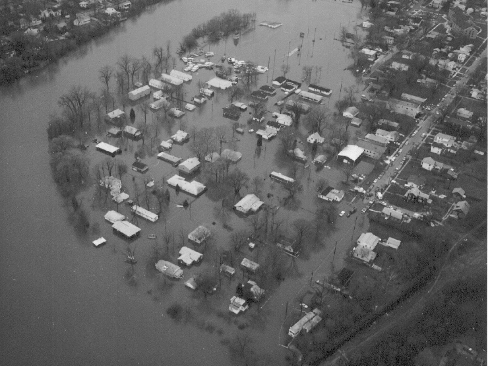
Once known as Louis Joliet's panoramic campground, the City of Ottawa, Illinois sits at the confluence of the two largest rivers in Illinois. For many years Ottawa was considered by the state and federal emergency agencys as one of the worse "repetetive loss communities" in the state. Ottawa's long history as a river town has brought with it the unfortunate impacts of environmental degradation. Clean up of radium from watch manufacturerers, coal tar from coal gassification operations and Chicago waste continues today. The new open floodplain has become a defining feature of Ottawa and the city leaders and citizens are committed to this new philosophy of embracing the river and returning the floodplain's natural function.
- Population Impacted: 20,000 +
- Continent: North America
Address
301 W. Madison
Ottawa, IL 61350
United States
Hazard
Identify the likelihood and frequency of this hazard
Explain how vulnerable the community is to this hazard
List the potential affects of this hazard
Identify how sensitive the community is to these affects
Preparedness Goal
Implementation Actions
After years of flood loss to the community, in the late 1990's the decision was made by the mayor and city council to address previous unwise development of the city's floodplain.. An aggressive buyout program was initiated. Fifteen years later the city has purchased more than 80 buildings, including a school. These properties have had all buildings removed and deed restricted to open space in perpetuity.
In 2009 a Flood Commission was formed. The community adopted higher regulator standards to include two additional feet of flood protection and compensatory storage of 1.5 to 1. Two years of public meetings produced a comprehensive Flood Threat Recognition and Response plan which is the highest rated program in the state. By engaging the community through a widley publisized effort of risk communication and education, the response was overwhelmingly positive.
In 2011 FEMA changed the Flood Insurance Rate Maps, raising the Base Flood Elevation 1.5'. Over 200 properties were affected by this map change. The outreach and education program empowered the community to successfully deal with a broad increase in the regulated floodplain.
By aggressive enforcement of higher regulatory standards the City saved millions in flood losses after the all time record flood of 2013.
By ordinance, our actions as a community are to "preserve the natural characteristics and function of watercourses and floodplains in order to moderate flood and stormwater impacts, improve water quality, reduce soil erosion, protect aquatic and riparian habitat, provide recreational opportunities, provide aesthetic benefits and enhance community and economic development.".
Describe Your Solution
At the community level, Ottawa's floodplain management team focused first on educating themselves. After becoming certified in floodplain management the City joined the Community Rating System and the Illinois Association of Floodplain and Stormwater Managers. Simultaniously, a flood commision was formed and new regulatory standards were adopted.
Entry into the CRS, adopting and enforcing higher regulatory standards and preparing a detailed Flood Threat Recognition & Response plan enabled our city to prevent millions of dollars in flood damage and returned over 40 acres of riverfront to open space. The community responded with overwhelming support for the city's floodplain management plans.
After the 2013 record flood, Senator Sue Rezin (38th District) saw first hand the devestation caused by flooding in her district which has over 100 miles of Illinois River & 40 miles of Fox River. In two counties alone there were over 150 million dollars in flood losses. She immeidaely questioned why the City of Ottawa was relativley undamaged. She asked if Ottawa would share with other communities andj quickly formed what is now the Illinois Valley Flood Alliance.
The premiss of the Alliance is fourfold, 1.) Adopt higher regulatory standards, 2.) Join the Community Rating System, 3) Interact with other organizations such as the Illinois Association of Floodplain and Stormwater Managers and 4. ) Have someone on staff become a Certified Floodplain Manager (education). The concept is simple--a community can be exceptional at managing their floodplain, however, unwise development up or downstream can have an adverse impact on that community. Having the communities hold one another accountable fosters the concept of a collaborative efffort at the community level. An April 2014 ASCE magazine report titled, "Flood Risk Management: The Need for Sound Policdies and Practices-- states "Flood risk managment provides for: collaborative risk sharing and risk management at all levels of government and by all stakeholders." Currently, 18 communities and 4 counties are part of this effort. The concept is now reaching further downstream as two legislators from other districts have expressed interest in furthing this cause.
Ottawa continues to make forward strides in its floodplain management. Currently Ottawa is preparing a "Program for Public Information".
Economic?
During the flood of 2013 Ottawa's planning saved the waste water treatement facility. Our hospital and high school suffered no damage. Upstream in Marseilles several barges broke loose and crashed into the dam. Resultantly nearly 400 homes were inundated with 4 feet of water. In Morris the aqueduct failed and the hospitaled flooded forcing evacuation and causing milliions in damages. Downstream two cities lost their waste water treatment facilities from flooding, costs to repair was over 20 million dollars. Several of their riverfront business remain closed today.
The demolition of the flood-ravaged Central School and subsequent purchase of the property by the City has left Ottawa owning 21 acres of Illinois riverfront. Consequently, the City has included a master waterfront development project in its updated Comprehensive Plan. The waterfront plan includes a small harbor, a significant entertainment venue, much greenspace and beautiful botanical gardens, space for commercial retail and residential development and an area set aside for civic facility development. Implementation of this plan during the next few years will be the catalyst for dramatic economic growth and new job creation in downtown Ottawa.
Environmental?
The Fox River Buy-out Program and the resulting demolition and removal of dozens of houses and buildings gave the City of Ottawa the opportunity to develop a beautiful new, 19 acre park along the scenic Fox River. The greenspace nature of Fox River Park has been further enhanced by the removal of the asphalt and concrete which formed the now un-needed streets in this former residential neighborhood. The Fox River now flows naturally through this area during its frequent flood stages. A river walk for biking and walking now connects this new park with downtown Ottawa.
What were the negative or unintended impacts (if any) associated with implementing this solution?
This may not be a truly negative result, but as the City of Ottawa built and strengthened its flood management program, the need for a variety of expensive flood infrastructure upgrades and mitigation projects became obvious.
Return on Investment: How much did it cost to implement these activities? How do your results above compare to this investment?
The Illinois Emergency Managment Agency was audited by the Institute for Bussiness and Home Safety. The audit revealed that for every dollar spent by a community on mitigating flood losses, four dollars are returned. The City of Ottawa has spent 1.8 million dollars mitgating flood prone buildings, educating the public about flood risks and deploying a Flood Threat Recognition & Response Plan.
As a result, during the flood of 2013, not only did the water rise 1.5 feet higher than any recorded flood and rise at a faster rate than ever recorded, the City was able to prevent a catastrophic loss to the Waste Water Treatment Facility. This facility was recently upgraded and would likely cost more than 22 million to replace.
What are the main factors needed to successfully replicate this solution
Successful Risk Communication begins at the community level. Collaboration between county, state and federal agencies initiated by the community fosters this process. Interaction with state and federal agencies introduces the community to programs that lead the community through the complex process of hazard mitigation grant funding, pre-disaster grant funding and the Community Rating System. The single most important step a community can take is to become members of the National Flood Insurance Program and the Community Rating System.