An Overview Of Our Solution
Over 300 acres of Chesapeake Bay shorelands are lost to erosion annually, primarily as a result of severe storms that elevate water levels and contain high wind speeds. Headland Control is a unique shoreline management technique whereby existing geomorphic features are enhanced with large stone breakwaters and/or large stone breakwaters are strategically placed along eroding coasts to create headlands. These enhanced or created shore headlands are widely spaced for economy. The adjacent coasts are allowed to continue to erode toward an equilibrium shore position or planform. The final equilibrium planform is a large pocket beach whose dimensions will depend on the amount of sand that will come to reside in the evolving embayment. Headland Control is applied to long reaches of agricultural or unmanaged woodland shores to begin the process of stabilization. With steadily rising sea levels and increased storm activity, addressing shoreline erosion along tidal water bodies like Chesapeake Bay will become even more important. Headland Control offers a cost effective means to manage eroding shorelines over time.
- Population Impacted: >100,000
- Continent: North America
Address
1375 Greate Road
Gloucester Point, VA 23062
United States
Hazard
Identify the likelihood and frequency of this hazard
Explain how vulnerable the community is to this hazard
List the potential affects of this hazard
Identify how sensitive the community is to these affects
Preparedness Goal
Implementation Actions
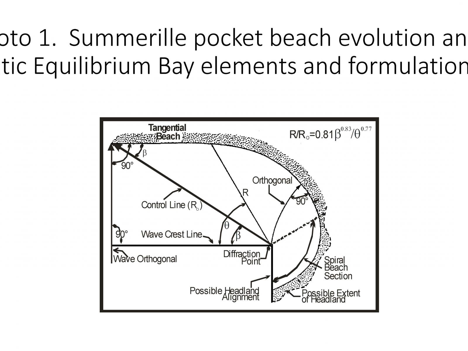
The use of Headland Control methodology is described in Photo 1. By knowing the net direction of wave approach, the shoreline evolution between fixed headland structures can be predicted.
Describe Your Solution
Most Chesapeake Bay shoreline is receding as a result of rising sea levels and wind driven waves often in combination with tidal currents. The greatest wave energy is generated during storm events. In the Bay region this is during northeasters and the occasional hurricane where elevated storm surge and large wind-driven waves combine to impact Bay shores at higher than normal elevations, cutting into upland banks and carrying off large quantities of bank sediments. Shore erosion, particularly along the upland banks, is greatest during storm events. It is storms that must be accounted for in developing shoreline management strategies for a given shore reach. Ultimately it is the embayed beach that becomes the primary element for shore protection. The design of embayed or pocket beaches shore planform should account for sand supply, wind, and tidal currents. Headland Control requires allowing the shoreline between breakwater units to evolve, essentially continue to erode toward equilibrium and therefore reducing shoreline erosion to zero. The Summerille site on the Potomac River evolved to what is called “dynamic equilibrium” as sand enters the embayment and provides a protective beach and dune system (Photo 2). Additional sand entering the embayment continues through the system to the downdrift coast. The St. Inigoes project is an example of Headland Control along about one mile of low farmland along Chesapeake Bay (Photo 3). Two other examples are provided at Hog Island, a wildlife management area in the James River (Photo 4) and the Murphy agricultural site on the Potomac River (Photo 5). Both sites are at equilibrium after about five and ten years of shoreline evolution, respectively. Other sites treated by Headland Control include historic Jamestown Island.
Economic?
Traditional shore protection methods such as stone revetments and breakwater systems cost upwards of $500 to $1,000 per linear foot of shoreline. However, by placing widely spaced stone headlands the cost per foot of structure is comparable but the cost per linear foot of shoreline is on the order of $200 to $300 and includes the rock for the headland structure and the sand behind it. This makes shore protection affordable to the average landowner, especially the farming community.
Environmental?
The Headland Control method enables the development of stable embayments over time. This allows for the evolution and ultimate creation of critical estuarine habitat including, but not limited to, tidal flats, beaches, dunes, and wetlands. In addition, the rock structures themselves become hard substrate for attached oysters as well as providing an area for foraging and shelter for numerous fish species.
What were the negative or unintended impacts (if any) associated with implementing this solution?
Headland Control must be designed and constructed so the potential “downdrift” impacts are addressed. This is accomplished by identifying where and how the impacts would occur and then either extending the project shoreline treatment to include those potential areas of impact or stopping the project short of those potential areas of impact so that the impact actually occurs on the project shoreline.
Return on Investment: How much did it cost to implement these activities? How do your results above compare to this investment?
The Summerille project spanned 700 linear feet and cost $100,000 for a cost per linear foot of $142. The St. Inigoes project spanned 5,000 linear feet and cost $1,000,000 for a cost per linear foot of $200. The Murphy project spanned 1,700 linear feet and cost $350,000 for a cost per linear foot of $205. These costs represent a considerable savings over traditional shore protection methods, which for these projects would have cost $3.7 million to $7.4 million. In addition, these figures do not account for the tax savings for local communities as a result of the Headland Control system’s abatement of the loss of taxable land.
What are the main factors needed to successfully replicate this solution
The Headland Control system has been utilized in 55 sites across the Chesapeake Bay watershed, including the sites depicted in the attached photographs. While the technique is widely and easily replicable, proper design of the system is critical and it will not be appropriate for all shorelines. Design elements include 1) an assessment of long term shoreline change using available data set of historical maps and aerial imagery, and 2) an assessment of the hydrodynamic forces operating along the project coast. The assessment of shoreline change through time provides a “picture” of the land’s response to the local wind-driven wave climate. This wave climate is assessed by measuring such things as fetch and nearshore water depths. These are major elements that influence the impinging waves at the site. Design guidelines have been developed by the project director and others that provide an empirical data base of successful projects. Two references are provided: Hardaway, Jr., C.S., and Gunn, J.R., 2010. Design and Performance of Headland Bays in Chesapeake Bay, USA. Coastal Engineering 57: 203-212. Hardaway, Jr., C.S., and Gunn, J.R., 2011. A Brief History of Headland Breakwaters for Shore Protection in Chesapeake Bay, USA. Shore & Beach 79(1): 26-34.