Home

Main Menu

  • About
  • Contests
    • Changing Unsustainable Trade
    • Water Pollution and Behavior Change
    • Climate Change Needs Behavior Change
    • Farming for Biodiversity
    • Reducing Our Risk
    • Adapting to a Changing Environment
    • Turning the Tide for Coastal Fisheries
  • Solutions
  • Impact
    • Growing indigenous seeds with pride
    • Honey shows the way in Ethiopia
    • Revitalizing oceans and communities
    • Solar Sister Entrepreneurs
  • Log in
  • English
  • Chinese, Simplified
  • Français
  • Español
  • Indonesian
  • Portuguese, Brazil
Farming for Biodiversity

Wildlife Conservation Society (WCS) Brasil

Campo Grande, 巴西
Close

An Overview Of Our Solution

WCS Brasil used a pilot municipality to demonstrate how sustainable land-use practices (SLUPs) can be both profitable and environmentally friendly alternatives to native habitat conversion and inefficient land-use practices in the threatened Cerrado highlands and closely linked Pantanal floodplain of central-western Brazil. With the goal of addressing harmful land use on private ranches and farms, we developed land-use management planning for a rural municipality that specified how proven SLUPs, combined with conservation and restoration measures, can be implemented on a municipal scale. We also used well-tested community outreach techniques to promote changes in land-use behavior as specified by the planning. Due to the success of the program, we are scaling it up to additional rural municipalities.
Who is this solution impacting?
Community Type
Rural
Rural
Additional Information
  • Population Impacted:
  • Continent: South America
General Information

Organization type

非盈利
Ecosystem (select all that apply)
Forests
Forests
Freshwater
Freshwater

Population impacted

Rural population in pilot municipality: 3400 ppl
Challenge

Size of agricultural area

Production area in pilot municipality: 1,700 km2 (65% of municipality)

Production quantity

210,000 head of cattle, 6.7 million liters of milk/yr, 2,400 tons/yr of soybeans in pilot municipality (2014 & 2015)

People employed

We are collaborating with approximately 1000 rural stakeholders and 20 pilot municipality personnel to develop and implement municipal planning. WCS employs 3 staff for project activities.
Solution

Describe your solution

To mitigate harmful land use and its consequences in the Pantanal and Cerrado, we worked with key regional stakeholders (see “External connections”) to develop and implement a systematic approach to promoting SLUPs that are profitable alternatives to native habitat conversions and inefficient practices on private lands. The approach ensures the economic sustainability of rural livelihoods by improving the efficiency and profitability on private properties. At the same time, we are protecting biodiversity, native habitats, and ecosystem function and services through municipal planning and effective outreach that promotes the implementation of conservation, restoration, and improved land-use measures. The approach includes: (1) conducting field-based research to identify innovative SLUPs that are both environmentally friendly and profitable; (2) developing land-use management planning that provides spatially-explicit municipal-scale solutions for implementing: (i) SLUPs in existing production areas, (ii) strengthened protections in native habitat areas, and (iii) restoration measures in degraded areas; (3) using proven community outreach techniques to promote implementation of municipal planning measures; and (4) monitoring key wildlife species and environments to evaluate conservation benefits from implemented measures.
Implementation

Describe your implementation

To inform municipal planning and promote transitions from harmful to SLUPs on regional ranches and farms, we tested and identified little-used or new practices that were both environmentally-friendly and profitable, e.g.: (i) rotational grazing and livestock watering systems that increase pasture quality, milk yield and cattle productivity, while conserving soil moisture and nutrients and avoiding erosion and water quality degradation associated with livestock impacts in riparian zones, and (ii) agroforestry restoration of degraded riparian zones that provides food crops to low-income farmers while protecting soil and water sources. By improving the efficiency and profitability of existing production areas, these proven SLUPs also eliminate economic justifications for additional native habitat conversions. To address the lack of regional land-use planning, we used Systematic Conservation Planning in collaboration with key partners to develop a land-use management plan for Corguinho. The plan provided spatially explicit municipal-scale solutions for implementing proven SLUPs and conservation and restoration measures that balanced the economic development and conservation objectives of municipal stakeholders. By developing municipal planning, rather than typical individual property planning, conservation efforts could be coordinated among a large number of properties simultaneously, producing outcomes that in the long term will be more effective at maintaining regional ecological function, environmental heterogeneity, and biodiversity. We promoted adoption of the planning among often skeptical landowners with outreach techniques that ensured greater uptake by the community. These included capacity building courses and events with landowner-to-landowner demonstrations of the economic and environmental benefits of SLUPs and other planning measures. Events also included neighboring municipality stakeholders to promote replication of successful Corguinho efforts.

External connections

Key partners in this project include: 1. Municipal governments, landowners, educators, and environmental councils of Corguinho, Rochedo and Rio Negro municipalities in Mato Grosso do Sul: Collaborative development and implementation of municipal land-use management planning, policy development, and community outreach. 2. Universidade Federal de Mato Grosso do Sul (UFMS) and Carbono Florestal: Consulting provided for ecological restoration projects. 3. UFMS, Instituto de Meio Ambiente do Mato Grosso do Sul (IMASUL) and Embrapa-Pantanal: Collaborative development and implementation of municipal land-use management planning, sustainable land-use practices, and ecological restoration projects. 4. Instituto Quinta do Sol (QDS) and Instituto Mamede de Pesquisa Ambiental e Ecoturismo: Collaborative development and implementation of community outreach techniques.
Results

What is the environmental or ecological challenge you are targeting with your solution?

The Pantanal and bordering Cerrado regions of central-western Brazil form an immense tropical wetland and forested-savanna ecosystem that sustain important populations of threatened wildlife and endemic species. With over 95% of the region comprised of privately owned ranches and farms, it is vulnerable to increasingly unsustainable development practices such as deforestation, native habitat conversion, and inefficient practices that drive more conversion. During the last 50 years, natural habitat conversion to planted pasture and crops and inefficient land-use practices have altered >60% of the Cerrado and >15% of the Pantanal. This harmful land use is responsible for biodiversity and ecosystem service losses, increased CO2 emissions, habitat fragmentation, accelerated soil erosion and stream siltation, altered flood patterns, and reduced quality of life for many rural community members. A significant barrier to addressing these problems has been a lack of regional land use planning.

Describe the context in which you are operating

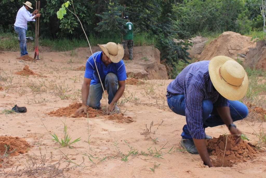
Key to preserving the Pantanal floodplain is protecting its headwaters in the Cerrado highlands. The 23,000 km2 project region in the Cerrado highlands comprises 3 headwater basins and 5 rural municipalities that supply a large portion of the water, nutrients, and sediments that form the southern Pantanal. Approximately 85% of agricultural area in the highlands region is comprised of large cattle ranches and crop plantations held by only 13% of landowners. The rest consists of small to medium dairy and mixed crop farms held by lower-income rural families. The majority of the population, 62% or about 23,000 people, is rural with a per capita income of $300 per month. Our surveys showed the urgency of launching measures to improve regional land use in the project-pilot municipality, Corguinho, finding that only 32% of native vegetation cover persisted and that 22% (380 km) of 1,697 km of stream and river channel did not have protective riparian (stream-side) vegetation zones.

How did you impact natural resource use and greenhouse gas emissions?

Through conservation, restoration, and improved land-use measures (specified by municipal land-use planning) and community outreach promoting changes in land-use behavior among regional landowners, the project will have positive impacts on regional environments and biodiversity over the next 5 years by: - increasing the connectivity and overall area of native habitat by 24 km2; - increasing habitat suitability and wildlife use of suitable habitat by 30% (140 km2) within native habitat remnants; - increasing the permeability of restored riparian zones and sustainably-managed production areas to wildlife movements (and dispersal by plants and animals in general); - increasing water quality and quantity along 380 km of stream channel; - increasing soil stability within 24 km2 of degraded riparian area; and - maintaining natural flooding patterns and flood-dependent ecosystem services provided by intact forest and stream environments.

Language(s)

Portuguese

Social/Community

Improved incomes and water quality on rural properties are resulting in new economic opportunities and health benefits, especially for low-income farmers and ranchers. These include the marketing of organically produced crops and native Cerrado fruits, avoidance of water-borne diseases, and greater access to health care

Water

Strengthened protections for riparian zones and streams are ensuring that water quality and quantity and riparian zone services are maintained for both biodiversity and rural livelihoods. Municipal planning includes restoring legally required 30 meter-wide riparian zones (increase of 24 km2), and eventually increasing riparian zone widths to 100 meters (increase of 110 km2). This along with protective fencing will reduce livestock and invasive exotic plant impacts.

Food Security/Nutrition

Agroforestry restoration projects that combine the planting of native tree seedlings with food crops (e.g., squash and watermelon) in riparian zones are improving food security and providing extra income for 50 low-income farming families in 2 subsistence farming communities. The projects also protect water supplies, soil, and other natural services

Economic/Sustainable Development

Improved land-use practices (SLUPs) in existing production areas of more than 30 properties are doubling milk yields, increasing beef cattle productivity by 15% and improving overall rural property economic returns, while maintaining soils and water sources. This prevents production area degradation and eliminates economic incentives and arguments for additional native habitat conversions.

Climate

Avoiding additional native habitat conversions will reduce principal sources of CO2 emissions in the region, i.e., the decay of toppled trees and soil carbon sources. Improved pasture and native habitat conditions resulting from use of rotational grazing systems will increase regional carbon sequestration. Greater protections established for native habitat, riparian zones, water sources and the services they provide will help regional biodiversity and rural communities adapt to climate change.

Sustainability

WCS will need additional grants ($50K/yr) to scale its activities. However, during the approximately two-year process of developing plans and promoting SLUPs in each municipality, ownership of project activities is gradually transferred to municipal governments and communities. This allows WCS to shift its focus to new municipalities and increase the sustainability and reach of the project. This transfer of ownership is achieved by building the capacity of municipal personnel to maintain project activities. The significant financial investments made by municipal governments during planning and outreach activities, as well as state funding opportunities for municipalities with developed land-use plans, also help motivate project transfer.

Return on investment

The return on investment for individual landowners in the project region can be measured by sustained improvements in productivity and reductions in operating costs as a result of implementing SLUPs and conservation and restoration measures. For example, the installation cost of large rotational grazing systems for beef cattle is returned over 5 years and accompanied by an 80% profit increase. For dairy farmers using cost-effective moveable electric fencing to set up small rotational grazing systems, the initial investment is returned and profits doubled within a year. For municipalities, current investments in conservation measures specified by planning will reduce future costs of restoration and climate change adaption projects.

Entrant Image

WCS Brasil Photo 2 - Pantanal Waterfall

Entrant Banner Image

WCS Brasil Photo 3 - Planting trees_0
Replication and Scale

How could we successfully replicate this solution elsewhere?

Successfully replicating land-use planning and outreach among regional rural municipalities is built in to our current program to replace harmful practices with sustainable land-use in the Cerrado highlands. The Systematic Conservation Planning approach and the planning software that we use, “Marxan with Zones,” have been proven effective in many other locations around the globe. In addition, we invite stakeholders from neighboring municipalities to participate in municipal planning and outreach events. This showcases pilot municipality innovations like planning, proven SLUPs, and capacity building, which motivates key stakeholders, including municipal government officials and representatives from landowner organizations, to initiate project activities in their own municipalities. WCS is currently scaling up the program from Corguinho to two neighboring municipalities, and a separate region in the southern Cerrado highlands.

YouTube URL

featured WCS’s Maria do Carmo A. Santos and Paulino de Oliveira Angelo
Overview
Rare
© 2025 Rare.
  • Terms of Use
  • Privacy Policy
  • Contact
back to top